Online Activities
Topographic Measurement
In planning for your field trip, you may want to discuss how long the tour will take, how long the trails are, and what the students may want to take with them. Decisions about what to take may be made more reliably by determining the length of the trails ahead of time. Click on the picture below to bring up a full sized view.
This may take a little time to load! If you have screen capture capabilities on your computer, capture the larger image and print it out. You can also print the picture directly from your browser to a laser printer. If you can't print the image, you may work directly on the screen. Have students determine the length of the trails by using a transparent metric ruler. The scale is approximately 2 millimeters = 40 feet.
Ice Cave Airflow Dynamic
There are many factors that keep the ice in the Ice Cave frozen over time. Can you determine from the information on our web site how this occurs? What would elevation, warm air/cold air physics, the seasons, and rock porosity have to do with it?
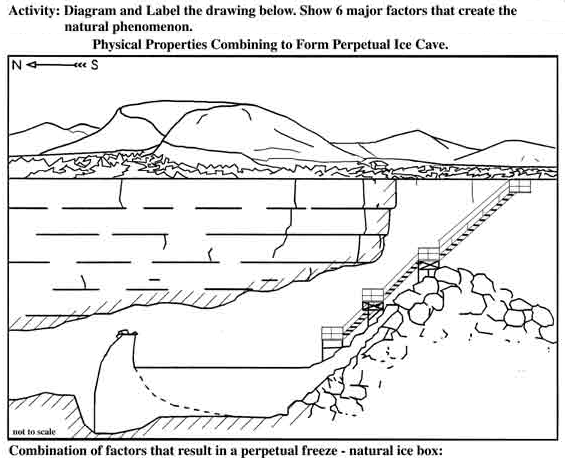
Before or after taking a field trip to the Ice Cave and Bandera Volcano, teachers may want to discuss with their students the dynamics of the Ice Caves's perpetual freeze. Print out the worksheet which represents a cross section of the cave, and color the drawing to represent the ice, lava, and air flow. Use the space below the drawing to discuss the factors causing the perpetual freeze. Click the download button below for a blank PDF. A password to the key is available upon request in person or using our contact page.


Ancient Artifacts and Pottery
The Ice Cave has been a gathering place for over 1200 years. We know this because of the artifacts left here by early man. Many stone artifacts and incredibly intact pottery pieces have been found in the area. All the artifacts and pottery pieces found by the Candelaria family have been preserved and displayed at the trading post. References to these items are in the Trail Guide and the Field Trip Data Sheet section of Education Corner.
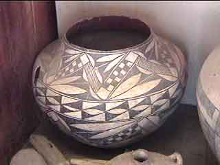
Before or after taking a field trip to the Ice Cave and Bandera Volcano, teachers may want to discuss with their students the historical significance of the pottery found around the Ice Cave area. We have a very general identification of the pieces in our display, but lack specific information on individual pieces. This activity invites you and your students to research individual pottery pieces like those shown below. This may be done through library research, internet research, or contacting professors of anthropology in your local area.
To examine and identify the Ice Caves pottery, use our gallery below. Each piece has a specific number, which you can reference when contacting the Ice Cave. We invite you to aid in identifying each piece as to type, age, and function. You may print out the individual pictures for close examination. As you identify each artifact, please e-mail us with your findings. We will post your research and findings on our website. We look forward to hearing from you.


Tree Ring Studies
Over the years, the Ice Caves has allowed many universities to come and make detailed studies of the Geology, Botany, and Biology of the area. One of the most recent groups to do this was the University of Arizona Tree Ring Laboratory. From their research we have learned that one of the oldest douglas fir trees in the area is along the Ice Cave trail. The age of this tree was determined by taking a core sample of the tree. Other tree ring studies were done that give a very good account of the forest fires that occured in the area over time. One such set of tree rings is shown below. The information below was gained from this research.
Fire-scarred Douglas-fir tree, by Henry D. Grissino-Mayer
This is a cross-section taken from a Douglas-fir tree that was killed by lightning sometime around 1952. This tree began its life on the slopes of Cerro Bandera, the cinder cone to the west of Bandera Crater, in the year 1640. During its 312 years, this tree would witness many events that changed the surrounding environment of the malpais. When the tree was only twenty years old, a forest fire swept through the area around the cinder cone, leaving a scar that provides tree-ring scientists the evidence needed to learn more about the history of past forest fires in the malpais. Many more forest fires followed. In all, this tree would record the occurrence of over 30 forest fires on the slopes of Cerro Bandera, or about one fire every ten years. Together with other trees collected, we now know that fire occurred on average about once every six years in this area of the malpais before white settlement began. Click the picture at left for a detailed image of the top section. Do you know what the arrows are pointing at?
Scientists now are aware that the forests of the American Southwest witnessed fire on a fairly regular basis during the last 400 years. However, because of grazing and fire suppression, the character of these forests changed during the last 100 years. Forest stands became unproductive and overstocked without fire to maintain the forest ecosystem, which also had a profound effect on wildlife. The type of information on fire frequency available from trees such as this Douglas-fir can be used by scientists to help reintroduce and restore fire in the forests of the Southwest. Without these low-intensity fires sweeping through and "cleaning" the forests, these stands become more and more susceptible to the high-intensity, catastrophic fires as forest fire "fuels," such as pine needles, twigs, large branches, and entire logs, build up to dangerous levels over time.
To try your hand at counting tree rings, we have provided slabs of Oak, Douglas Fir, and Ponderosa Pine below. Just click on each picture to bring up a virtual tree ring core. Counting begins at the left in each core image, just scroll your browser window to count the rings. Each of the slabs is approximately 3 to 3.5 inches in diameter, and grew within 50 feet of each other. How old is each tree?
Additional Resources:


Tree Identification
The Ice Caves has a number of trees that are typically found between 7000 and 8000 feet elevation. From the pictures of tree branches below, classify them as Evergreen or Deciduous. Hints as to the names of the trees can be found throughout the web site. Explain what Evergreen and Deciduous mean.
Before or after taking a field trip to the Ice Cave and Bandera Volcano, teachers may want to discuss with their students the type of trees that will be found here. During a field trip, compare leaves/needles found along the trail with a pintout of this page.


